By Graham J. Clarke
February 2001 (Internet: 19 September, 2004)
INTRODUCTION
I have re-evaluated the count data collected during the East Pacific Gray whale population counts of 1967-1968 to 1968-1970 at Yankee Point and Point Loma, California in an effort to explain the difference in count numbers between the two sites and re-assess the total Pacific East Coast Gray whale population size for this period.
In order to evaluate the Yankee Point and Point Loma count we must first examine the count discrepancies between the two locations. This method of "double-sampling" with locations 465kms apart may have been discontinued from 1970 due to the inability to explain, without much estimation, this discrepancy.
According to Reilly (1984:216) using "paired observers": "People vary widely in their accuracy and precision in estimating both number [of Gray whales] and distance [to the whale]." Rugh (1990:119*) concluded that shore-based count discrepancies must include a "portion of the [Gray whale] population present in the viewing area, but missed by each observer". The error becoming more apparent when the animals were close to shore (within 0.5 km).
Neither Reilly (1984) or Rugh (1990) concluded that either pair/site was more accurate than the other and that "double-sampling, as described in the stud[ies] may provide a measure of consistency within a database".
My conclusion then, as to the accuracy of the Yankee Point and Point Loma counts, must be that the two counts are correct and that an "other" factor must be at work either diminishing the Point Loma data and/or inflating the Yankee Point data.
BACKGROUND
The analysis of the Yankee Point and Point Loma data with summary was published by "The American Society of Mammalogists" as 'Special Publication No.3' by Dale W. Rice and Allen A. Wolman.
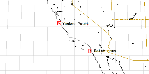
Quote: "During the southward migration in 1967-68, 1968-69, and 1969-70, coastal lookout stations were established to count migrating whales. One was on Point Loma at San Diego, California (32°40' N lat.), 130 meters above sea level (Rice, 1961) and is the site where pervious counts were made (Gilmore, 1960a, 1960b; Rice, 1961). The second station was 2km. S Yankee Point, Monterey Co., California (36°29' N lat.), 23 meters above sea level and about 100 meters back from the shoreline. This was near the site where a partial count of migrating Gray whales was made in 1966-67 (Adams, 1968). Observations were made continuously from 0700 to 1700 hours (essentially sunrise to sunset) each day." (Rice & Wolman, 1971)
Their conclusions were as follows:
"Estimates of total population size, based on (our) corrections (conclude that) the Yankee Point estimates are probably more accurate than the Point Loma estimates, because of the greater possibility of error in adjusting for offshore migration at Point Loma."
Estimate of whales passing during daylight
| 1967-68 | Yankee Point | 3,724 |
| Point Loma | 1,560 | |
| 1968-69 | Yankee Point | 4,500 |
| Point Loma | 1,653 | |
| 1969-70 | Yankee Point | 4,544 |
| Point Loma | no count |
(Table 14, p112)
"The California Gray whale population was probably at least 8,000 but less than 13,000 during the southward migration in 1969-70, with 11,000 being the most reasonable estimate."
To reach their conclusion Rice and Wolman had to solve the count discrepancy. They did it this way -
In an effort to explain the differences Rice and Wolman decided that:
(p113) "The 1967-68 and 1968-69 counts at Point Loma were 44 and 51 per cent, respectively, below the 1959-60 count of 2344. Either some factor such as increase in small boat traffic has caused a larger proportion of the population to pass farther offshore at Point Loma, or the population in the 1959-60 actually was much higher than estimated and has decreased."
(p109) "To calculate the total population size from these counts, we must estimate the number of whales that were missed because of poor visibility, the whales that passed too far offshore to be seen, and the whales that passed at night."
Rice and Wolman decided to investigate the possibility that "whales too far offshore" might be the factor that caused the count discrepancy since misses due to poor visibility and whales that passed at night were constant at both locations.
(p110) "To determine the number of whales passing too far offshore to be seen, we ran transect cruises from Yankee Point and Point Loma across the migration path of the whales. In a transect from Yankee Point on 18 January 1968, extending 37 kms offshore, no Gray whales were seen farther from shore than 6 kms., and only 9 of the 33 whales sighted were beyond 4.5kms from shore. The remaining 24 were within 1.5kms of land."
(p111) "Between 25 January and 9 February 1968, we ran 7 transects totalling 1572kms between Point Loma and longitude 119°20' W, just beyond Tanner and Cortez Banks. During 100kms of cruising within 9.3kms of shore, 37 Gray whales were seen, an average of 0.37 per kilometer cruised. During 1472 kilometers of cruising beyond 9.3kms fro shore, 40 Gray whales were sighted, an average of 0.027 per kilometer."
This was their answer to the count discrepancy:
"The width of the migration path at this latitude [Point Loma] is at least 194.5 kilometers" and "The ratio of whales passing offshore to those passing within sight of land is thus 5 : 3.44. This ratio indicates that only 41% of the whales migrating south past southern California passed within sight of Point Loma. This agrees with our estimates of 35% to 42% based upon a comparison of the Point Loma and Yankee Point counts".
There it was the answer to the count discrepancy. It took 6 extra transects at Point Loma and an extra 157kms out-to-sea, 5 times the distance travelled at Yankee point but now the numbers added up.
A NEW LOOK
Throughout this document I will use Rice and Wolman's own references as published. Only the conclusions Rice and Wolman make in respect of aspects of migration and population numbers are challenged here.
(p13) "Migrations-Pike(1962a) summarized all published information on the migration route of the Californi population and presented significant new data. There are few observations on southward-migrating whales in the northern part of their range. From October through January, they probably move down the eastern side of the Bering Sea, go through Unimak Pass, and then follow the coast to Baja California. A few go around Cabo San Lucas and cross to the eastern side of the Gulf of California."
"Our observations during whale marking cruises off California and Baja California show that the majority of Gray whales migrate within a few kilometers of shore when passing points, headlands, and sectors of coastline where the Continental Shelf is narrow and there are no off-lying islands. Many tend to take the most direct route, however, when crossing bights, and indentations of the coastline."
If Pike's migration summary is correct, and there is no reason to believe it is not, then why, after travelling close to 18,000kms, do Gray whales suddenly dispurse for the last few hundred kilometers of their migration only to regroup at journeys end?
(p111)"The width of the migration path at this (Point Loma) latitude is at least 194.5 kilometers..."
********************
Migrating Gray whales do not dispurse! They do not dispurse because Gray whales are creatures of habit. Rice and Wolman believe they dispurse because it fits their equation. It solves their problem and validates the count data.
At the beginning I said that I believed that the two counts were correct and that an "other" factor must be at work. But what?
It is generally agreed that Gray whales do not slow down at night, 95% stay within 1.9 kilometers of the coastline and all travel at a constant speed throughout their more than 18,000 kilometer migration.
(p15) "There is no consistant hourly variation in the number of Gray whales migrating south past the counting stations, contrary to the opinion of Ramsey (1968). This lack of variation indicates that Gray whales, on the average, maintain a constant speed throughout daylight hours. (Rice and Wolman,1971)
The answer, to the count discrepancy, is in the count data and as you will see the Point Loma count is not inaccurate (as suggested and corrected in the study) and there were negligiable whales "too far out-to-sea" to count as with Yankee Point so no correction is necessary again). All you have to believe is that at some point north of Yankee Point some Gray whales are detoured or delayed for a period every 24 hours.
If both the Yakee Point and Point Loma counts are correct then the proportion of whales detoured/delayed can be calculated:
| Season | Place | Count | Delayed | Actual | Proportion |
| 1967-68 | Yankee Point | 3724 | 1082 | 3724-1082 = 2642 | 0.290547 |
| Point Loma | 1560 | 1560+1082 = 2642 | |||
| 1968-69 | Yankee Point | 4500 | 1424 | 4500-1424 = 3076 | 0.316334 |
| Point Loma | 1653 | 1653+1424 = 3076 |
Using the same proportion for 69-70 as 68-69 (no delay increase) Hi range:
| Season | Place | Count | Delayed | Actual | Proportion |
| 1969-70 | Yankee Point | 4544 | 1437 | 4544-1437 = 3106 | 0.316334 |
| Point Loma | [1669]# | 1669+1437 = 3106 |
[#] calculated = 'Actual' minus 'Delayed')
As you can see it is possible to calculate what the 1969-70 Point Loma count would have been.
Using a constant increase in delay [0.31 + (0.31-0.29)] Low range:
| Season | Place | Count | Delayed | Actual | Proportion |
| 1969-70 | Yankee Point | 4544 | 1555 | 4544-1555 = 2989 | 0.342121 |
| Point Loma | [1435]# | 1435+1555 = 2989 |
[#] calculated = 'Actual' minus 'Delayed')
My 1969-70 lower limit indicates a decrease in the whale count so the asumption of a constant increase in detoured/delayed whales may not be realistic. A more practical increase may be closer to reality.
(Practical)
Using a more practical increase in delay (0.3201 a modest increase)
| Season | Place | Count | Delayed | Actual | Proportion |
| 1969-70 | Yankee Point | 4544 | 1455 | 4544-1455 = 3089 | 0.3201 |
| Point Loma | [1635]# | 1635+1455 = 3089 |
[#] calculated = 'Actual' minus 'Delayed')
The only thing left to do is adjust the numbers to cover the full 24 hours.
(p111) "Because there is no evidence that migrating Gray whales slow down at night, we have multiplied the estimated number of whales passing during the 10 hours of daylight during which counts were made by 2.4 to estimate the total number of whales passing each counting station during each of the two seasons." (Rice and Wolman, 1971)
| Season | Place | Count | Actual | TOTAL = (Actual x 2.4) |
| 1967-68 | Yankee Point | 3724 | 2642 | 6341 |
| Point Loma | 1560 | 2642 | ||
| 1968-69 | Yankee Point | 4500 | 3076 | 7384 |
| Point Loma | 1653 | 3076 | ||
| 1969-70 | Yankee Point | 4544 | 3106 (no increase in delay) | 7456 |
| Point Loma | [1669]# | 3106 |
[#] calculated 'Actual' minus 'Delayed')
I can now define this "other" factor.
(p127) "Migrating Gray whales swim at about 8.5 kms per hour; on the southward migration they travel about 185 kms per day. There is no evidence that the whales travel slower at night than during the daylight."
(p15) ". . . [The whales] average speed during the 10 hours of daylight is 8.5kms per hour." (Rice and Wolman, 1971)
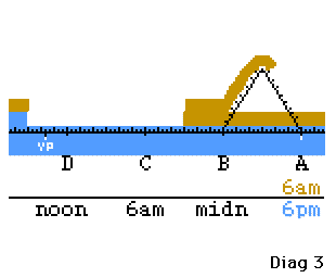
If some of the southbound migrating Gray whales make a detour at some point north of Yankee Point and travel only 16 kms further out to sea and back in again (See diagram 2) they will effectively travel 100.5 kms. At 8.5 kms per hour that detour will take them 12 hours while the straight through trip (32 kms) will only take 4 hours. The result presenting itself as a layered effect. The delayed group subtracted from the actual group over half the period and added to the actual over the other half. (See diagram 3)
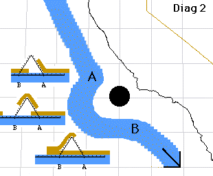
If the detour/delay is human induced then it most probably happens during daylight hours and since the count occured during daylight (0700 to 1700) the frequency of increased numbers to decreased numbers will be at that frequency. If the detour/delay occurs over 12 hours that would be the period and observers would see the same part of the cycle every day.
We can also calculate where in the cycle the Yankee Point and Point Loma observations were and where the cycle most likely started.
The cycle begins
| Off Yankee Point (YP) | located | 36°29'N lat. 121°59'W long. | |
| Off Point Loma (PL) | located | 32°40'N lat. 117°20'W long. | |
| YP to PL = 601kms (as the crow flys) | (Xerox PARC Map Viewer http://www.indo.com/distance/) | ||
| But the whales need to go around Point Conception 34°30'N 120°40'W | |||
| YP to 34°30'N | = | 250kms | (Xerox PARC Map Viewer http://www.indo.com/distance/) |
| 34°30'N to PL | = | 370kms | (Xerox PARC Map Viewer http://www.indo.com/distance/) |
| ------------ 620kms ------------ |
|||
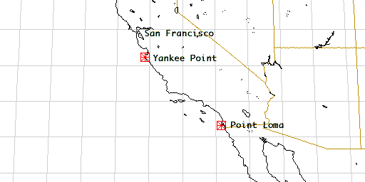
Point Loma is 620 kms south of Yankee Point.
(p15 Rice and Wolman, 1971) "The average speed of Gray whales along their entire migration route, calculated from dates of peak passage at various points along the coast, is about 185kms per day, or 7.7kms per hour on the southward migration. . ." (Pike, 1962a)
1 Whale Day = 185kms
Distance YP to PL = 620 / 185 = 3.35 Whale Days (or cycles)
From the above we can see that at near 3 and a half cycles when Yankee Point sees the increased period Point Loma sees the decreased period.
We can now determine the most likely position of the detour/delay.
If Yankee point is a whole 'whale travelling day' or a complete number of cycles from the detour/delay site then this will be the Yankee Point cross over where the number of whales changes from the low amount to the high amount. If the detour/delay occurs at 6am then the changeover occurs at 6am (0600hrs) at Yankee Point and about 6pm (1800hrs) at Point Loma.
(p10) "Observations were made continuously from 0700 to 1700 hours (essentially sunrise to sunset) each day." (Rice and Wolman, 1971)
This indicates that the Yankee Point observers may have just missed the change-over every day and counted, for at least the next 10 hours, an unvaring high component of 'Actual' plus 'Detoured' whales whereas the Point Loma observers counted an unvaring low component of 'Actual' minus 'Detoured' whales.
The detour/delay site needed to fulfill these requirements will be one 'Whale Day' or multiple of 'Whale Days' north of Yankee Point ie. multiples of 185kms.
| Off Yankee Point | 36°29'00"N 121°59'W | |
| Off San Francisco | 37°45'35"N 122°37'W | |
| SF to YP = 152kms (as the crow flys) | (Xerox PARC Map Viewer http://www.indo.com/distance/) | |
| but the whales need to go around headlands at 37°12'N 122°25'W | ||
| YP to 37°12'N | = 66kms | (Xerox PARC Map Viewer http://www.indo.com/distance/) |
| 37°12'N to PL | = 89kms | (Xerox PARC Map Viewer http://www.indo.com/distance/) |
| ----------- 155kms ----------- |
||
San Francisco Bay is 155 kms north of Yankee Point or 83.8% of a Whale Day.
CONCLUSION
Over the period 1967 to 1988 a number of annual counts were made using three different counting methods. 1967-1968 to 1969-1970 two individual counting positions were used - Yankee Point and Point Loma. Then annually to 1970-1980, with additional counts in 1984-1985, 1985-1986 at one position, Monterey CA. And finally, 1987-1988 at one position (Monterey) with two independent stations 5.1 metres apart (Buckland 1993).
Heavy shipping traffic moving in and out of San Francisco Harbour during daylight hours disrupts the path of the migrating Gray whales forcing some of them to move further offshore to circumnavigate the region in a wide circle. At night, when shipping traffic is minimal or non-existent all the approaching Gray whales move straight on through without hesitance or impediment (maintaining a constant speed).
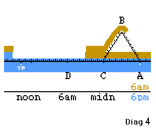
Therefore, in its simplest form; whales approaching the cause of the detour/delay during daylight hours follow the path A, B, C, D and at night they follow the path A, C, D. (See diagram 4). The daytime path (for calculation purposes) around the detour (circle) is 3.1428 (pi) times longer than the night-time path.
My re-evaluation of the data collected during the Gray whale counts of 1967-1968 to 1968-1970 at Yankee Point and Point Loma indicates that the true census of Gray whales for this period was 7,456 (corrected to 9,394 Rugh 1993) and not the 11,000 estimated by Rice and Wolman.
RECOMMENDATIONS
- 1. A study needs to be done to provide proof that Gray whales avoid the region adjacent to San Francisco Heads. Two transects needs to be done from San Francisco Heads west for 195 kms (121 miles) to match the Point Loma transects. If the two figures are not consistant a third transect will be needed.
- 2. How far offshore is the Continental Shelf? This may be the whales safety zone.
- 3. Find out what time most vessels move through the SF heads. No curfew - Port open 24 hours a day since 1835 (excluding wars possibly). More traffic 0500 to 1700hrs.
Notes:
- A third counting point during the three periods would have been worth its weight in gold!
- Why was there no Point Loma count in 1969-70?
BIBLIOGRAPHY
- * David J. Rough, Richard C. Ferrero & Marilyn E.Dahlheim. 1990. Inter-Observer Count Discrepancies in a Shore-based Census of Gray Whales , Marine Mammal Science, vol6, no2.
- Dale W. Rice & Allen A. Wolman. 1971. The Life History and Ecology of the Gray Whale, The American Society of Mammalogists. No.3